Appalachian Trail Journals: Connecticut, Massachusetts, and Vermont
These journals were originally published on my Instagram between July 11 and July 23, 2021.
Day 57 | 19 miles | 1463-1482
I impressed myself this morning by waking up before sunrise without an alarm, but wasn’t so happy when I realized that I had to flick away dozens of slugs that had oozed their way onto my groundsheet and bivy. But I did get rid of them and made my way up Schaghticoke Mountain, excited to get my first view of the Connecticut landscape. Turns out that the area was still socked in by clouds when I got up there, which I guess is a view in its own way.
In the late morning, I met a hiker from Florida named Hitching Post and we teamed up to make good time up and down Mount Algo and Fuller Mountain. We also compared notes on what it’s like to work as an engineer versus a lawyer, especially in the context of taking time off to go backpacking.
I separated from Hitching Post and made my way down from the top of Calebs Peak on a very steep stone staircase right along what would naturally be an unwalkable rock slab. It’s pretty amazing the things that have been built to make these National Scenic Trails go where they do.
The steep steps brought me down to the west shore of the Housatonic River where I met three hikers from Brooklyn and Chicago and a former thruhiker named Armadillo who was giving out cold juice. I continued with the crew on some incredibly cruisey and flat trail along the river, chatting away like thruhiking was the easiest thing in the world.
In the early afternoon, I said goodbye to my new friends and walked a couple miles on a quiet country road to get to the little village of Cornwall Bridge to rest and resupply. I walked past picturesque farm houses and cow pastures and really enjoyed it. Although the main draw for me to visit the Appalachian Trail was the backcountry, I like the quiet roadwalks too because they give me a window into how life is being lived in this part of America.
Day 58 | 18 miles | 1482-1500
I woke up at the Hitching Post Hotel in Cornwall Bridge and felt really sad to look out the window and see another morning of pouring rain. I realized this was a trend, because it wasn’t the first time I felt this way the morning after sleeping indoors on this hike. I guess when I see the rain from inside a cozy room as opposed to from inside my tent on trail, my brain knows this whole thing is voluntary and just nopes out of it.
But by the end of the morning, I reluctantly got back on trail. I wasn’t into it for the first few miles, but the thing that ended up bringing me back to earth was taking pictures. It’s not really intentional, but I guess the practice of creating art based on the beautiful things around me can help keep me in the present and out of my own head.
I felt better and kept moving along, but encountered a few water crossings that had been simple rock hops up until a week ago, but were now knee-deep fords because of all the recent rain. For the first few crossings, I looked for rocks and logs to cross on and keep my socks dry, but eventually getting my feet wet was inevitable. Some beavers had dammed a stream, flooding the whole area and making it impossible to cross without a ford.
Despite the tough start to the day, I ended up having a great afternoon after meeting up with the same four hikers I had walked with yesterday. We managed the rest of the stream crossings together, and it felt great just to commiserate together about the tough conditions. It put things into perspective and made me feel grateful when I heard from three of them that their tents had flooded in this morning’s rainstorm while I was lucky enough to be indoors.
After I said goodbye to my new friends and continued on my own through the evening, it was a pretty civilized experience walking through the neighbourhoods and hydro power infrastructure of Falls Village. The highlight was seeing Great Falls on the Housatonic River, which the locals told me barely flows at all below the dam at this time of year. Now, after tropical storm Elsa, the intensity of flow was epic.
Day 59 | 26 miles | 1500-1526
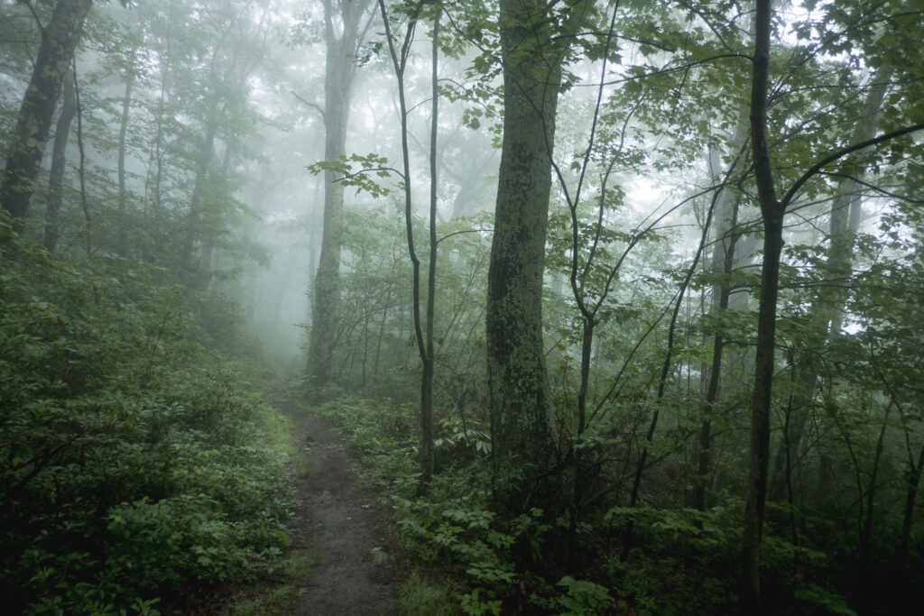
On my final day in Connecticut, I was given a reprieve from the rainy weather. But I did still have to deal with the lingering effects of all the recent rainfall, like flooded trails and swollen brooks that needed fording. A dense fog blanketed the whole landscape, giving it a mysterious feel.
I started my day walking on roads and easy trails in the outskirts of the town of Salisbury. I didn’t go into town, but passed by some charming homes and farms, and even the local cemetery. Afterwards, I went up and over Bear Mountain, the tallest summit in Connecticut. I didn’t see any views because of the fog, but it was a fun and engaging hike over some very steep terrain. It was extra challenging because the rock was slick from the rain last night and days prior.
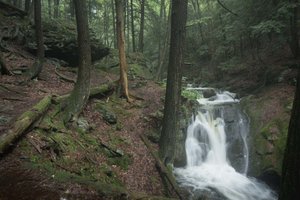
The highlight of the day was walking through Sage’s Ravine, a narrow corridor of Hemlock forest where the Appalachian Trail runs along the fast-flowing Sawmill Brook, and across a handful of cascades that feed into it. At the north end of the ravine, I crossed the state line into Massachusetts. Despite the challenging conditions and lack of views, I really liked the trail through Connecticut. The terrain was so varied and interesting, the water crossings were a fun new challenge, and the locals were very friendly.
Massachusetts brought more steep, rocky climbs in and out of the fog, and more wet trail. Being socked in the mist like that all day gave me the sensation of being out there all in my own. And I actually only saw a handful of other hikers today.
In the evening, I walked through pastures and flat, flooded forests where the mosquitos got pretty gnarly. Thankfully, I was able to make it back up into the mountains away from the worst of the bugs before setting up camp for the night.
Day 60 | 26 miles | 1526-1552
I woke up at my camp on the slopes of June Mountain in a thick morning mist, which I think contributed to me sleeping in way past sunrise once again. Once I got moving, it was beautiful to watch the process of the sun burning through the mist and shining on all the dewy forest foliage.
As I head north, coniferous trees are becoming more common and giving the forest and different look and smell. Sometimes, the trail is blanketed in needles and gives the walking a whole new feel.
The mud and wetness of the previous days continued today, and I found myself moving much more slowly than I’d have expected based on the elevation profile for the area. There was one section around Tyringham Cobble where it was so muddy I was worried it would suck a shoe off my feet, making for some challenging hiking.
While I was crossing a rural road near the village of Tyringham, I was surprised to notice a little shed with the words “Trail Stand” painted on it a ways up the road from the trail crossing. I walked up to it curiously and was stoked to realize that it was full of cold sodas, snacks, and fresh fruit for sale. And it was all on an honour system of leaving cash in an envelope.
There’s a saying in the long-distance hiking world that goes “The trail provides” that has proven itself to be true time and time again on this trail. Because I had been moving slower than expected to my next resupply, I was planning to have to go hungry and be low on calories for the next couple days, but after coming across the Trail Stand, I was all set.
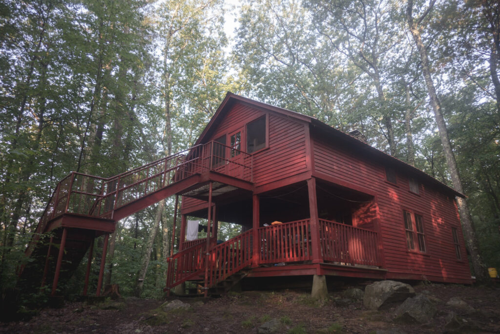
In the evening, storm clouds that had been threatening all day finally manifested and dumped a bunch of rain on my head, along with some lightning that felt not at all far away. I put my rain gear on and made my way to the cabin at Upper Goose Pond, where the bunks were unfortunately full but the caretakers let me sleep on the covered porch to stay out of the elements.
Day 61 | 25 miles | 1552-1577
I woke up at the Upper Goose Pond Cabin and had a great start to my day with blueberry pancakes and hot coffee made by the volunteer caretaker from the Appalachian Mountain Club. After breakfast, I walked down to the dock to check out the sunrise over the misty lake and was stoked to see that the weather forecast for clear skies was accurate.
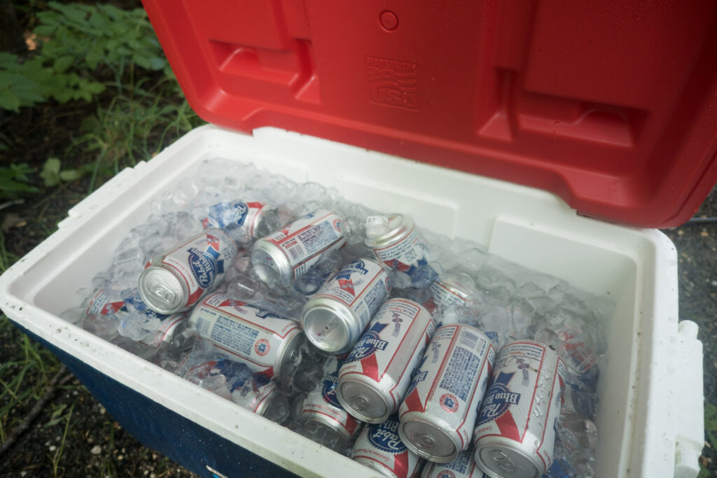
It wasn’t long after I started hiking, as I was making my way up Beckett Mountain, that I came across a cooler with the words “Have a blessed day” on it full of ice and cans of PBR. Pancakes, sunshine, and beer? It was indeed going to be a blessed day.
In the early afternoon, I got another morale boost when I stopped by “The Cookie Lady”, a group of blueberry farmers that, in addition to selling blueberries, make homemade cookies and lemonade for hikers on a donation basis. All these little steps ended up being key to keeping my spirits high today, because the trail was muddier and wetter than ever, which didn’t make for very pleasant hiking.
All the trudging through the mud and trying not to slip onto my butt eventually started to really tire me out into the afternoon. But just in time, I found myself in the town of Dalton where I stopped for dinner and a beer at Dewey’s Public House to refuel and take a break from the mud. After dinner, the trail continued through the neighbourhood streets of Dalton and I had the chance to see all the locals enjoying the sunny evening on their front porch, and even spectate an inning of the local baseball game.
North of town, it was like someone flipped a switch and the trail wasn’t muddy at all. I happily continued on the dry trail to the Crystal Mountain Campsite where I set up camp as the sun was setting. Even though I was at one of the few designated campsites in Massachusetts, there was only one other hiker there, I guess because we were so close to town.
Day 62 | 20 miles | 1577-1597
I woke up at Crystal Mountain Campsite way later than expected, which has been a persistent trend for the last week or so. I seem to be in a kind of funk that involves sleeping a lot and generally being low in energy. But I still feel healthy and stoked on the goal of walking to Maine. I’ve been through this enough times as a competitive runner to know that with enough sleep, food, and patience, I can make it through to the other end of this without even necessarily resting.
In the late morning, I made it to the viewpoint of Cheshire Cobble where I had a great view over the town and towards the Taconic Mountains. I stopped to soak it in and enjoy the nice breeze in the sun, realizing this was the first time I had a real view across the landscape around me in many days.
Afterwards, I made my way down into Cheshire, walking on sidewalks through neighbourhoods on my way to the store to resupply. I’ve enjoyed walking right through these little towns the last couple days and having the opportunity to check out daily life in New England.
All afternoon, I worked my way up Mount Greylock through a dense Hemlock forest that smelled amazing and reminded me of home in coastal Canada. The summit of the mountain, the highest in the state, was a pretty special place, with panoramic views in all directions. I climbed the 90 steps to the top of the War Memorial Tower, a lighthouse dedicated to the people of Massachusetts that died in World War 1. I also visited Bascom Lodge and Thunderbolt Shelter, beautiful old stone structures built in the 1930s.
After my descent off Greylock, I set up camp at the Sherman Brook Campsite and enjoyed a campfire-my first in a while-with a group of other thruhikers and traded stories about our experiences on the AT and other trails. At the end of the day, I reflected on the fact that today was the first day in a while that I was really able to enjoy the scenery and my environment without having to deal with rain, bugs, or mud and finally just chill on the trail. I think that’ll help me break out of this funk.
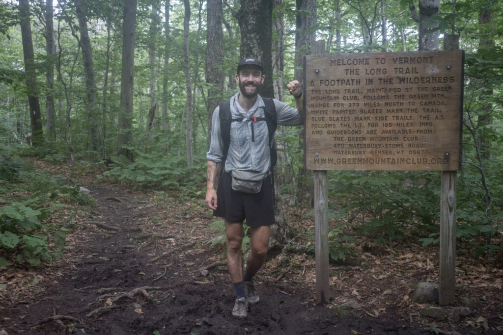
Day 63 | 27 miles | 1597-1624
Just a couple miles after starting this morning, I crossed the state line into Vermont. For the next hundred or so miles, the Appalachian Trail shares the same path as the Long Trail, America’s oldest long-distance hiking trail. I’m excited to meet a whole new cohort of thruhikers and see what Vermont has in store.
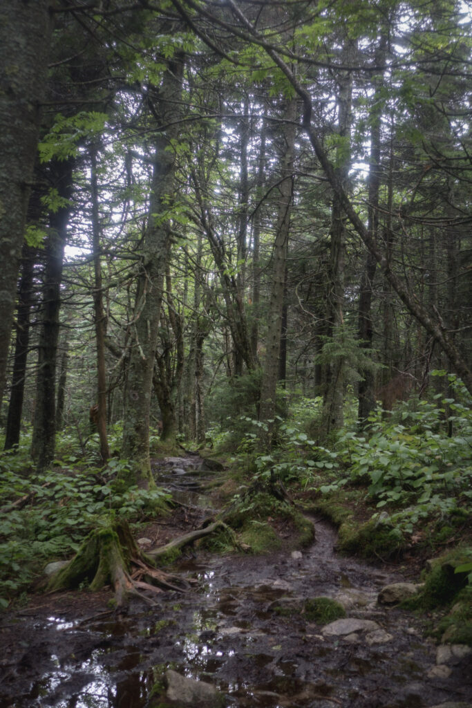
True to its nickname Vermud, the trail was very wet as soon as I crossed the state line, and I trudged through the mud through the morning and afternoon. I made decent progress but honestly wasn’t having much fun since the mucky conditions and complete lack of views through the forest canopy made for unrewarding walking.
But when I crossed VT Route 9 at Woodford Hollow after descending a bunch of steep stone steps, I had the good fortune of getting some cold sodas and fine conversation with a family of trail angels calling themselves the Trail Servants. After a nice little rest, I set off up into the Green Mountains reinvigorated.
The trail angels gave me a sticker with a bible reference on it (Mark 9:35) that I was able to look up later on when I got some cell service. To paraphrase, I think it says that to find success in your own life, you’ve got to focus on helping other people. It’s something that’s been demonstrated to me more times than I can count by the amazing people I’ve met on this trail. It’s also something that I completely understand but have struggled to internalize at times when my own obstacles and problems can feel like the most important things in the world. Anyway, the Vermont mud certainly felt more manageable after meeting the Trail Servants.
In the evening, I could hear a storm coming in, so I hauled ass up through the Glastenbury Wilderness trying to make it to the Goddard Shelter before it started pouring. I surprised myself with how quickly I was able to move up the mountain this late in the day, especially given how tired I had felt earlier. But in the end, the storm caught me just minutes before I made it to the shelter, which ended up being full anyway, so I set up my tent in the rain.
Day 64 | 21 miles | 1624-1645
It rained pretty much all last night, and I woke up today with debris all over my gear from the splashing, plus dozens of slugs oozing their way over everything I owned. It was a tough way to start the day, and so it was once again mid morning before I got moving on the trail.
The rainy and muddy conditions continued throughout the day, making it tough to keep my spirits up. Most of the day’s walking was through slippery ankle-deep muck. Overall, I’m not sure I would describe what I’ve been going through out here for the last week or two as “fun”, but I still feel stoked on finishing what I set out to do and continue to feel like this is a worthwhile experience. Despite it all, I think I’m very lucky to be out here thousands of miles from home, pursuing my hobby in nature with the support of both my loved ones at home and the trail community out here. There’s really nothing I’d rather be doing. Except maybe, you know, hiking the Appalachian Trail in dry conditions.
It’s not all doom and gloom. I still managed to find moments of bliss throughout the day, like climbing to the top of the fire tower on Glastenbury Mountain, staring out through the clouds and seeing the treetops from above. Or standing on the side of a beaver bog watching the raindrops ripple across the surface. Or hanging out in the Stratton Mountain fire tower on my own in the middle of a cloud, feeling like I could have been the only person in the world.
At the end of the day, I walked a short stretch with a hiker named Fireball. She’s been a lot more social than me, and was able to let me know that morale is in the shitter for every northbound thruhiker in the area. It was actually encouraging to hear that it wasn’t just me that was having a tough time trying to enjoy these conditions.
Day 65 | 22 miles | 1645-1667
Once again, it rained hard the entirety of last night, making for a pretty fretful sleep. However, when I packed up and got moving this morning through the Lye Brook Wilderness I surprisingly felt more energetic and spirited than previous days. Maybe all these long nights in my tent taking shelter from the rain meant I was very rested.
The trail was as wet as ever, with near-constant ankle-deep mud and puddles making up the trail. I also thought it was raining all morning, but when I got to a clearing in the trees I realized it wasn’t raining at all, it’s just that all the moisture that had accumulated on the foliage last night was falling on me. I regularly came across running water sources not even shown on the map that were flowing across the trail up to my shins, and this was pretty close to the summits of nearby mountains! The amount of water that’s fallen on this area recently is something else.
The highlight of the day was making it to the summit of Bromley Mountain, a ski resort. By some miracle, the sun came out while I was up there and gave me a chance to spread out all my gear to dry off, giving me a much-needed opportunity to reset for the days ahead. I relaxed in the clearing on the summit amongst the wildflowers and chairlifts and enjoyed the view of the Vermont landscape, my first since crossing the state line.
After Bromley, I traversed lush, forested ridge lines in the Peru Peak Wilderness. The forest floor and all the fallen trees were covered in moss and it was clear to me why this area was called the Green Mountains.
In the evening, I walked on endless boardwalks on the shore of Griffith Lake and watched the setting sun reflect off the water’s surface in a deep orange hue. Afterwards, I entered Big Branch Wilderness and climbed up Baker Peak to make camp for the night. When I got up there, I found a rocky summit under a clear sky with great views to the west, and was stoked on the idea of cowboy camping at the top. I can’t think of a better contrast to all the rain and mud of the previous days than sleeping out in the open.
Day 66 | 27 miles | 1667-1694
I couldn’t see any stars from my camp on Baker Peak last night, and when I woke up this morning I realized it was because I was sleeping inside a cloud, which was a neat experience in its own right. I packed up and descended through Big Branch Wilderness through a dense, lush forest until I reached Big Branch itself. The trail ran along the shore of the fast-flowing water for a while before crossing it on a beautiful timber suspension bridge.
Once I left the wilderness area, the trail got easier and made its way towards Little Rock Pond and I decided to go for a really refreshing dip despite the cloudy weather. Life’s too short to not swim in backcountry lakes when you find them.
I continued through the late morning and early afternoon through peaceful and sunny Pine and Hemlock forests that were more sparsely treed that of southern Vermont, and also blissfully dry. For the first time on this trip, I met someone that started at the southern terminus of the AT later than me. Her name was Trash Crab and she was doing the trail in a supported style. It was fun to really pick up the pace for a few miles and chat with her about the experience, but since she was literally running it didn’t take long before I got dropped and was back to my usual pace.
In the late afternoon, I made it to the road crossing at VT Route 103 and walked a bit off trail to Goucheberg Farms Market and Deli, which was a really friendly and welcoming family-run place, for a sandwich and light resupply. Afterwards, I walked on pleasant trails up and over the steep Beacon Hill and made my way to the Governor Clement Shelter. There, if you can believe it, after nearly 1700 miles, I’ll sleep in an AT shelter for the first time. It was just me, another hiker named Bruce and his huge but adorably friendly dog Forest. We made a fire in the shelter’s fireplace and watched and listened as a storm of biblical proportions descended on the area. It was awesome and comfortable to watch the lightning and listen to the rain from inside the shelter.
It was a great day, the best I’ve had on the AT in a while.
Day 67 | 13 miles | 1694-1707
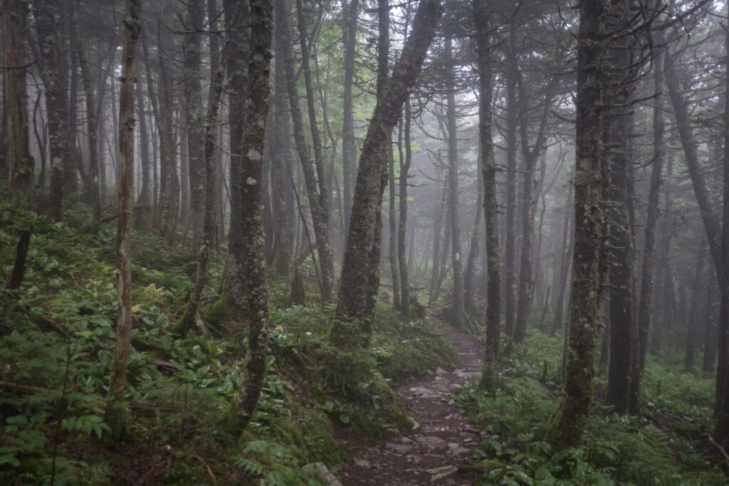
I woke up early today at Governor Clement Shelter, said goodbye to my shelter buddy for the night Forest the dog, and set off up and over Killington Peak. It’s a popular ski resort and the second-highest mountain in Vermont and in no time at all it felt like I was walking in the clouds. When I got to the top, I opted to skip the side trip to the true summit because it was clear I wouldn’t be able to see anything from up there.
So I continued down the other side of the mountain through more mist and over trails that were extra wet from last night’s deluge. In the late morning, the Appalachian Trail diverted from the Long Trail, meaning that I would see far fewer other backpackers from now on compared to the previous hundred miles as I headed east towards New Hampshire and the Long Trail hikers continued north towards Canada.
At the end of my hiking day, I unexpectedly found myself among camper vans and tent trailers in Gifford Woods State Park. I hadn’t really been around people enjoying the outdoors that way so far on my journey, and it made me nostalgic for car camping trips with my family from years past.
Once I made it to VT Route 100, I walked a mile or so to the resort town of Killington where I planned to resupply and have a day of rest and relaxation at the Greenbrier Inn. It was going to be my first night indoors in over 200 miles, and I was pretty stoked for it.
Day 68 | 26 miles | 1707-1733
I was happy to have got off trail for a night in Killington and experience the people and places of Vermont outside of the narrow scope of the Appalachian Trail. I’m glad I took at least a day to talk to the friendly locals and take in the charm of the tourism industry. Now that I don’t think of Vermont as just muddy trails and cloudy mountain summits, I’m feeling pretty stoked on the state overall.
Rested and refreshed, I hit the trail and cruised all morning over wooded viewless mountains and just kept on cruising until coming to an unnamed seasonal water source just north of Stony Brook Shelter. Because of all the recent rain and the way the water flowed through the rock just right, it had created a perfect little swimming hole, and I went for a dip.
I remember coming across similar places in the South during the first month of this journey and just walking right on by, maybe out of some compulsion to make miles for the day or maybe just not feeling like getting wet in this humid climate. But I guess the challenges of the last couple weeks have taught me that these peaceful wonder-filled experiences in the wilderness are so far from a given that I need to take advantage of them when presented with the opportunity. And I also guess getting wet doesn’t phase me anymore.
In the afternoon, I visited The Lookout, a cabin that’s actually on private property but has owners that are fine with hikers using it. I had no plans to stay the night but really loved climbing the ladder to a crow’s nest on the roof with panoramic views.
Through the evening, I had some great conversation with other hikers. First, I walked a few miles with Hambone, a hiker who has completed the AT over three times in addition to a bunch of other trails. We shared some funny stories and he let me pick his brain about all the experience he’s accumulated on his adventures. After I said bye to Hambone, I made my way to a great open campsite on a meadow above Pomfret Road where I met a hiker named Play Doh who had started his thruhike in May just like me, and we compared experiences hiking on the AT faster than most.
Day 69 | 27 miles | 1733-1760
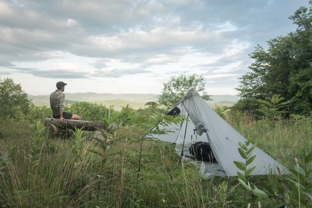
Through the morning, I descended the eastern foothills of the Green Mountains, my home range for the last week or so. There were a few short, punchy climbs and couple decent views over grassy meadows, but it was mostly easy trail through wooded areas. I moved quickly and was in a great mood, excited to finish up the Vermont section of the AT.
In the early afternoon, the trail spat me out into a rural neighbourhood in the town of Norwich, and I walked past some really beautiful houses in a very charming part of town. I got the sense that some very wealthy Vermonters lived around here. I headed into the town centre and resupplied at the friendly Dan and Whit’s General Store, and I also packed a box of food to send up the trail to a rural hostel. I embraced my hikertrash identity by spreading out a whole week worth of food right on the pavement of the post office parking lot, getting organized while the locals went about their business around me.
After that, I was all set and walked across the Connecticut River into New Hampshire. It felt like a pretty big moment crossing into the state that many hikers consider the most beautiful on the whole Appalachian Trail, and the penultimate state of my journey. My first stop in New Hampshire was Hanover, the home of the Ivy League Dartmouth College. The campus was beautiful, and it was fun to explore like a complete tourist past all the college buildings and even the high-end shopping district. It was probably the first place I’ve visited on the AT that felt like many people around me had no clue what a dirty, bearded man with a backpack was doing walking around.
After enjoying some pizza and local craft beer at Ramunto’s Pizzeria in town, I hit the trail. My first afternoon and evening in New Hampshire was just going up and down wooded hills and through some small pastures, classic Appalachian Trail. I got stormed on a little, but not enough to get soaked, and continued until sunset when I set up close to Mink Brook where I could fall asleep to the sound of running water.
Read the next chapter of my Appalachian Trail journals from New Hampshire and Maine here.